


Third Military Survey 1:25,000
The Map Collection owns valuable original manuscripts of topographical sections mapping the territory of Bohemia, Moravia and Silesia on a scale of 1:25,000. The maps come from the years 1876-1879 (so-called Third Military Survey or Franz-Joseph Survey). These map sheets were taken together with about 30,000 other documents in the period of the First Republic from the Vienna archive.
The sheets of the topographical sections were first recorded in the card catalog, now they are cataloged in the Central Catalog of Charles University, and their scans are made available in the Digital Library Kramerius CU.
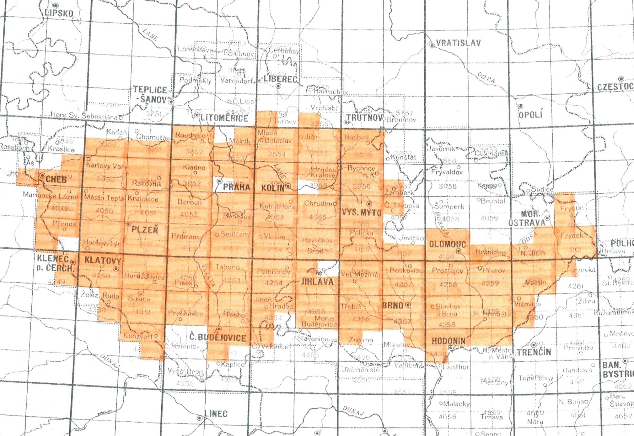
Overview of 236 manuscript originals of 1:25,000 topographical sections owned by the Map Collection:
Literature on manuscript originals of the third military survey:
BOGUSZAK, František and Jan, CÍSAŘ. Mapování a měření českých zemí od poloviny 18. století do počátku 20. století. Praha: Ústřední správa geodézie a kartografie, 1961. 80 s.
KUCHAŘ, Karel. Mapové prameny ke geografii Československa. Acta Universitatis Carolinae : Geographica, 1967, roč. 2, s. 57-97.
KUCHAŘ, Karel. Naše mapy odedávna do dneška. Praha: Nakladatelství Československé akademie věd, 1958. 129 s.
KUPČÍK, Ivan. Z dějin geodézie a kartografie. Z pozůstalosti mapových originálů III. vojenského mapování. Geodetický a kartografický obzor, 1976, roč. 22, č. 5, s. 147-148. Dostupné zde.
KUPČÍK, Ivan. The State Map Collection in Prague. Imago Mundi. 1983, roč. 35, č. 1, s. 103-104. ISSN 0308-5694.
MIKŠOVSKÝ, Miroslav and Bohumil ŠÍDLO. Topografické mapování našeho území ve 20. století. In: 14. kartografická konference. Úloha kartografie v geoinformační společnosti, 11. – 13. září 2001 v Plzni. Plzeň, 2001 [cit. 2015-03-17]. Available zde.
NOVOTNÁ, Eva. Třetí vojenské mapování: vybrané problémy první české katalogizace. In: ŠVEJDA, Antonín (ed.). Rozpravy Národního technického muzea v Praze. 1 vyd. Praha: Národní technické muzeum, 2015. ISSN 0232-0916.