Old maps portal - StaréMapy.cz
Be a part of the processing of old maps and discover a world long forgotten! Find identical points on the old and the new maps, and the maps will appear over each other. You can compare the changes in the landscape and find the extinct villages or increasing cities.
The StaréMapy.cz portal offers all volunteers the opportunity to georeference digitized old maps from major Czech collections including the CU FS Map Collection. You too can join and see how your world was viewed in maps of the past compared to today! On the StaréMapy.cz website you have access to several thousand maps for processing. The results of this project will be used for additional research and will also make it possible to perform visual searches in map collections.
 The instructional video
The instructional video showing how to georeference an old map was created in collaboration with Charles University and the Moravian Regional Library. The video can be viewed on the StaréMapy.cz website, on YouTube, or the Facebook profile of the project.
In addition to the video is also available presentations with instruction and demonstration work on the portal Starémapy.cz (only in Czech).
The technology behind the project is the Georeferencing tool, which can be used by Internet users to easily create 3-D visualizations, overlay maps on current satellite images and compare changes to individual areas over time.
The CU FS Map Collection joined the StaréMapy.cz project on March 21st, 2013 on the occasion of the opening ceremony for the newly renovated collection space.
Map Collection contributes to the project gradually, depending on the digitization of its collections. During the exports for 2015 has been added 14,498 maps from the collection. Over the duration of the project, a total of 29,966 maps has been added, which is half of the total number of maps to be processed from 18 different isntitutions (60,710, as of 19. 4. 2016).
Georeferencing in practise
In the Week of Geography, Faculty of Science was held in November 2015 in the Library of Geography practical workshop with a demonstration of georeferencing. Students in primary and secondary schools could try to work with old maps under supervision.


Contest for georeferencing old maps
As part of the StaréMapy.cz project there have already been 2 rounds of the contest for georeferencing old maps, which has enjoyed tremendous public response. Contestants who georeferenced the most maps, or clicked on the greatest number of identification points, received valuable prizes with an historical cartography theme such as a copy of the map of Europe by Evert Gijsbertsz from 1598, a copy of the map of Moravia by Jan Amos Komenský, or a catalog to the exhibition Treasures of the Map Collection.
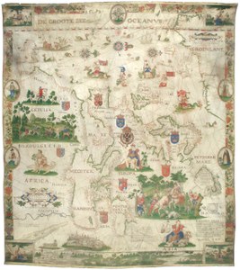 Evert Gijsbertsz - Europe, 1598
(Source: Map Collection)
Results of the 1st round of the contest (March/April 2013)
- Winner: Vladimír Říský
Results of the 2nd round of the contest (27. 11. 2014 - 31. 1. 2015)
- 1st place: Ondřej Dedek
- 2nd place: Jaroslav Lehečka
- 3rd place: Milada Jirásková
Document Actions